Download Oracle Spatial 11g Essentials.1z0-595.PracticeTest.2017-12-14.39q.vcex
| Vendor: | Oracle |
| Exam Code: | 1z0-595 |
| Exam Name: | Oracle Spatial 11g Essentials |
| Date: | Dec 14, 2017 |
| File Size: | 713 KB |
How to open VCEX files?
Files with VCEX extension can be opened by ProfExam Simulator.
Discount: 20%


Demo Questions
Question 1
Which function call would return the area of a geometry, geom1, in square kilometers?
- SDO_GEOM.SDO_AREA(geom1, .05)
- SDO_GEOM.SDO_AREA(geom1, .05, ‘unit=SQ_KM’)
- SDO_GEOM.SDO_AREA(geom1, ‘unit=SQ_KM’)
- SDO_GEOM.SDO_AREA_SQ_KM(geom1, .05)
- SDO_GEOM.SDO_AREA_SQ_KM(geom1)
Correct answer: B
Explanation:
SDO_GEOM.SDO_AREAFormatSDO_GEOM.SDO_AREA( geom IN SDO_GEOMETRY, dim IN SDO_DIM_ARRAY [, unit IN VARCHAR2] ) RETURN NUMBER;orSDO_GEOM.SDO_AREA( geom IN SDO_GEOMETRY, tol IN NUMBER [, unit IN VARCHAR2] ) RETURN NUMBER;DescriptionReturns the area of a two-dimensional polygon.ParametersgeomGeometry object.dimDimensional information array corresponding to geom, usually selected from one of the xxx_SDO_GEOM_METADATA views.unitUnit of measurement: a quoted string with unit= and an SDO_UNIT value from the MDSYS.SDO_AREA_UNITS table (for example, 'unit=SQ_KM').If this parameter is not specified, the unit of measurement associated with the data is assumed. For geodetic data, the default unit of measurement is square meters.tolTolerance valueReferences: https://docs.oracle.com/database/121/SPATL/sdo_geom-sdo_area.htm#SPATL1110 SDO_GEOM.SDO_AREA
Format
SDO_GEOM.SDO_AREA(
geom IN SDO_GEOMETRY,
dim IN SDO_DIM_ARRAY
[, unit IN VARCHAR2]
) RETURN NUMBER;
or
SDO_GEOM.SDO_AREA(
geom IN SDO_GEOMETRY,
tol IN NUMBER
[, unit IN VARCHAR2]
) RETURN NUMBER;
Description
Returns the area of a two-dimensional polygon.
Parameters
geom
Geometry object.
dim
Dimensional information array corresponding to geom, usually selected from one of the xxx_SDO_GEOM_METADATA views.
unit
Unit of measurement: a quoted string with unit= and an SDO_UNIT value from the MDSYS.SDO_AREA_UNITS table (for example, 'unit=SQ_KM').
If this parameter is not specified, the unit of measurement associated with the data is assumed. For geodetic data, the default unit of measurement is square meters.
tol
Tolerance value
Question 2
You have defined a number of Web Map Service (WMS) and Web Feature Service (WFS) themes by using the MapBuilder tool of Oracle MapViewer. Which two actions can you perform with those themes?
- Overlay a WMS theme with the data from your database.
- Overlay a WMS theme with the data from a WFS theme.
- Perform SQL searches on the WFS themes.
- Reproject the WFS geometries to a different coordinate system.
- Copy data from a WFS theme into your database.
Correct answer: AD
Explanation:
A: Regardless of what type of data is associated with a theme (except for WMS themes, which represent externally rendered map layers), the MapViewer styling rules still need to be defined for each theme, and the styles referenced by the styling rules must exist and be stored in the database as part of the mapping metadata.D: A WFS theme is a special kind of MapViewer theme that supports the rendering of data delivered using the Open GIS Consortium (OGC) Web Feature Service (WFS) protocol, specifically the WFS 1.0.0 implementation specification.WFS theme are conceptually similar to geometry themes, and users are able to render and label features. The WFS operations GetCapabilities, DescribeFeatureType, and GetFeature are used when rendering a WFS theme. When a WFS service is accessed, MapViewer caches the information about capabilities and feature types. References: https://docs.oracle.com/cd/E12839_01/web.1111/e10145/vis_concepts.htm#JIMPV9548 A: Regardless of what type of data is associated with a theme (except for WMS themes, which represent externally rendered map layers), the MapViewer styling rules still need to be defined for each theme, and the styles referenced by the styling rules must exist and be stored in the database as part of the mapping metadata.
D: A WFS theme is a special kind of MapViewer theme that supports the rendering of data delivered using the Open GIS Consortium (OGC) Web Feature Service (WFS) protocol, specifically the WFS 1.0.0 implementation specification.
WFS theme are conceptually similar to geometry themes, and users are able to render and label features. The WFS operations GetCapabilities, DescribeFeatureType, and GetFeature are used when rendering a WFS theme. When a WFS service is accessed, MapViewer caches the information about capabilities and feature types.
References: https://docs.oracle.com/cd/E12839_01/web.1111/e10145/vis_concepts.htm#JIMPV9548
Question 3
Identify four OGC vector data formats that Oracle Spatial can translate to and from natively.
- GML
- SHP
- WKT
- WKB
- GWT
- KML
Correct answer: ACDF
Explanation:
Oracle Spatial provides different types of converters to convert the geometry data to GML (both Version 2.1 and Version 3.1.1), KML, and the well-known text and binary (WKT and WKB) representations. These converters are provided as PL/SQL functions and Java APIs. References: https://www.safaribooksonline.com/library/view/applying-and-extending/9781849686365/ch02s07.htmlhttps://docs.oracle.com/database/121/SPATL/sdo_util-from_wktgeometry.htmhttps://docs.oracle.com/database/121/SPATL/sdo_util-to_wkbgeometry.htm#SPATL1250 Oracle Spatial provides different types of converters to convert the geometry data to GML (both Version 2.1 and Version 3.1.1), KML, and the well-known text and binary (WKT and WKB) representations. These converters are provided as PL/SQL functions and Java APIs.
References: https://www.safaribooksonline.com/library/view/applying-and-extending/9781849686365/ch02s07.html
https://docs.oracle.com/database/121/SPATL/sdo_util-from_wktgeometry.htm
https://docs.oracle.com/database/121/SPATL/sdo_util-to_wkbgeometry.htm#SPATL1250
Question 4
Which two requests will you use to update records in a catalog that is published via the Catalog Service for the Web (CSW)?
- GetRecords
- GetRecordsWithLock
- Transaction
- Harvest
Correct answer: CD
Explanation:
Operations defined by the CSW standard include:Transaction (optional): create/edit metadata by 'pushing' the metadata to the serverHarvest (optional): create/update metadata by asking the server to 'pull' metadata from somewhereGetCapabilities: "allows CSW clients to retrieve service metadata from a server"DescribeRecord: "allows a client to discover elements of the information model supported by the target catalogue service. The operation allows some or all of the information model to be described".GetRecords: search for records, returning record IDsGetRecordById: "retrieves the default representation of catalogue records using their identifier"GetDomain (optional): "used to obtain runtime information about the range of values of a metadata record element or request parameter"Note: Catalog Service for the Web (CSW), sometimes seen as Catalog Service - Web, is a standard for exposing a catalogue of geospatial records in XML on the Internet (over HTTP). The catalogue is made up of records that describe geospatial data (e.g. KML), geospatial services (e.g. WMS), and related resources.References: https://en.wikipedia.org/wiki/Catalog_Service_for_the_Web Operations defined by the CSW standard include:
Transaction (optional): create/edit metadata by 'pushing' the metadata to the server
Harvest (optional): create/update metadata by asking the server to 'pull' metadata from somewhere
GetCapabilities: "allows CSW clients to retrieve service metadata from a server"
DescribeRecord: "allows a client to discover elements of the information model supported by the target catalogue service. The operation allows some or all of the information model to be described".
GetRecords: search for records, returning record IDs
GetRecordById: "retrieves the default representation of catalogue records using their identifier"
GetDomain (optional): "used to obtain runtime information about the range of values of a metadata record element or request parameter"
Note: Catalog Service for the Web (CSW), sometimes seen as Catalog Service - Web, is a standard for exposing a catalogue of geospatial records in XML on the Internet (over HTTP). The catalogue is made up of records that describe geospatial data (e.g. KML), geospatial services (e.g. WMS), and related resources.
References: https://en.wikipedia.org/wiki/Catalog_Service_for_the_Web
Question 5
What does Oracle Spatial use to generate the R-tree spatial index entry for a polygon geometry?
- the perimeter of the geometry
- the minimum bounding rectangle of the geometry
- the number of ordinates in the geometry
- the area of the geometry
- SDO_GTYPE of the geometry
Correct answer: B
Explanation:
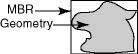
A spatial R-tree index can index spatial data of up to four dimensions. An R-tree index approximates each geometry by a single rectangle that minimally encloses the geometry (called the minimum bounding rectangle, or MBR), as shown in figure below. For a layer of geometries, an R-tree index consists of a hierarchical index on the MBRs of the geometries in the layer, as shown in the figure below. 1 through 9 are geometries in a layer. a, b, c, and d are the leaf nodes of the R-tree index, and contain minimum bounding rectangles of geometries, along with pointers to the geometries. For example, a contains the MBR of geometries 1 and 2, b contains the MBR of geometries 3 and 4, and so on. A contains the MBR of a and b, and B contains the MBR of c and d. The root contains the MBR of A and B (that is, the entire area shown). References: https://docs.oracle.com/cd/B28359_01/appdev.111/b28400/sdo_intro.htm#SPATL459 A spatial R-tree index can index spatial data of up to four dimensions. An R-tree index approximates each geometry by a single rectangle that minimally encloses the geometry (called the minimum bounding rectangle, or MBR), as shown in figure below.
For a layer of geometries, an R-tree index consists of a hierarchical index on the MBRs of the geometries in the layer, as shown in the figure below.
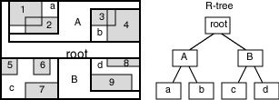
1 through 9 are geometries in a layer.
a, b, c, and d are the leaf nodes of the R-tree index, and contain minimum bounding rectangles of geometries, along with pointers to the geometries. For example, a contains the MBR of geometries 1 and 2, b contains the MBR of geometries 3 and 4, and so on.
A contains the MBR of a and b, and B contains the MBR of c and d.
The root contains the MBR of A and B (that is, the entire area shown).
References: https://docs.oracle.com/cd/B28359_01/appdev.111/b28400/sdo_intro.htm#SPATL459
Question 6
Which command will load a shapefile named states.shp by using the GDAL/ORG command-line utilities? Assume that the database name, username, and password are mvdemo.
- gdal_translate –of oracle mvdemo/mvdemo@mvdemo states.shp
- ogr2ogr –f OCI:mvdemo/mvdemo@mvdemo states.shp
- ogr2oracle –f OCI mvdemo/mvdemo@mvdemo states.shp
- ogr2oracle –f ORACLE mvdemo/mvdemo@mvdemo states.shp
- gdal_translate –of OCI mvdemo/mvdemo@mvdemo states.shp
Correct answer: B
Explanation:
Example Simple translation of a shapefile into Oracle. The table 'ABC' will be created with the features from abc.shp and attributes from abc.dbf. % ogr2ogr -f OCI OCI:warmerda/[email protected] abc.shpReferences: http://www.gdal.org/drv_oci.html Example
Simple translation of a shapefile into Oracle. The table 'ABC' will be created with the features from abc.shp and attributes from abc.dbf.
% ogr2ogr -f OCI OCI:warmerda/[email protected] abc.shp
References: http://www.gdal.org/drv_oci.html
Question 7
Which two are benefits of partitioning in Oracle Spatial?
- reduced CPU utilization
- reduced network utilization
- query parallelism
- faster index builds
- reduced storage needs
Correct answer: CD
Explanation:
Partitioning is used in data management solutions to address issues of manageability, scalability, and performance C: Here are some Oracle partitioning capabilities that can enhance scalability and performance:Search multiple table or index partitions in parallel Spread the I/O load associated with table or index accesses across multiple controllers Store data physically on disk so that data that is likely to be processed together is close together on disk Eliminate partitions from consideration based on a partition key D: There are many meaningful benefits of partitioning to enhance manageability in a DBMS solution.These benefits include the ability to:Backup data on a partition-by-partition basis Restore data on a partition-by-partition basis Load a partition at a time Store data in different tablespaces on a partition-by-partition basis Rebuild indexes on a partition-by-partition basis References: http://download.oracle.com/otndocs/products/spatial/pdf/spatial_wp10_bestprac.pdf, page 4 Partitioning is used in data management solutions to address issues of manageability, scalability, and performance
C: Here are some Oracle partitioning capabilities that can enhance scalability and performance:
- Search multiple table or index partitions in parallel
- Spread the I/O load associated with table or index accesses across multiple controllers
- Store data physically on disk so that data that is likely to be processed together is close together on disk
- Eliminate partitions from consideration based on a partition key
D: There are many meaningful benefits of partitioning to enhance manageability in a DBMS solution.
These benefits include the ability to:
- Backup data on a partition-by-partition basis
- Restore data on a partition-by-partition basis
- Load a partition at a time
- Store data in different tablespaces on a partition-by-partition basis
- Rebuild indexes on a partition-by-partition basis
References: http://download.oracle.com/otndocs/products/spatial/pdf/spatial_wp10_bestprac.pdf, page 4
Question 8
Identify two compression types that are not natively supported by GeoRaster, but are supported through the Lizardtech GeoRaster plugin.
- BMP
- MrSID
- JPEG 2000
- ECW
- TIFF
- JPEG
Correct answer: BC
Explanation:
Oracle Spatial GeoRaster 10g Release 2 provides a plugin architecture to support wavelet compression schemes such as those from LizardTech. Users who install the LizardTech plugin may compress GeoRaster objects using any of three wavelet compression types:MrSID Generation 2, MrSID Generation 3 and LizardTech JPEG 2000. References: http://doc.lizardtech.com/uploads/2012/02/georaster-lizardtech-mrsid-129598.pdf Oracle Spatial GeoRaster 10g Release 2 provides a plugin architecture to support wavelet compression schemes such as those from LizardTech. Users who install the LizardTech plugin may compress GeoRaster objects using any of three wavelet compression types:
MrSID Generation 2, MrSID Generation 3 and LizardTech JPEG 2000.
References: http://doc.lizardtech.com/uploads/2012/02/georaster-lizardtech-mrsid-129598.pdf
Question 9
In Spatial Analysis and Mining, what does the term binning mean?
- binary searches
- partitioning data by size
- compressing data
- simple sort
- classifying data based on location
Correct answer: E
Explanation:
The spatial analysis and mining features in Oracle Spatial let you exploit spatial correlation by using the location attributes of data items in several ways: for binning (discretizing) data into regions (such as categorizing data into northern, southern, eastern, and western regions), for materializing the influence of neighborhood (such as number of customers within a two-mile radius of each store), and for identifying colocated data items (such as video rental stores and pizza restaurants).References: https://docs.oracle.com/cd/B28359_01/appdev.111/b28400/sdo_sam_concepts.htm#SPATL070 The spatial analysis and mining features in Oracle Spatial let you exploit spatial correlation by using the location attributes of data items in several ways: for binning (discretizing) data into regions (such as categorizing data into northern, southern, eastern, and western regions), for materializing the influence of neighborhood (such as number of customers within a two-mile radius of each store), and for identifying colocated data items (such as video rental stores and pizza restaurants).
References: https://docs.oracle.com/cd/B28359_01/appdev.111/b28400/sdo_sam_concepts.htm#SPATL070
Question 10
What is the following query best suited for?

- listing partitions by size
- visualizing the partitions
- clustering the partitions
- virtualizing the partitions
- normalizing the data
Correct answer: B
Explanation:
Sdo_aggr_mbr returns the minimum bounding rectangle (MBR) of the specified geometries, that is, a single rectangle that minimally encloses the geometries. References: https://docs.oracle.com/database/121/SPATL/sdo_aggr_mbr.htm Sdo_aggr_mbr returns the minimum bounding rectangle (MBR) of the specified geometries, that is, a single rectangle that minimally encloses the geometries.
References: https://docs.oracle.com/database/121/SPATL/sdo_aggr_mbr.htm
HOW TO OPEN VCE FILES
Use VCE Exam Simulator to open VCE files
HOW TO OPEN VCEX AND EXAM FILES
Use ProfExam Simulator to open VCEX and EXAM files

ProfExam at a 20% markdown
You have the opportunity to purchase ProfExam at a 20% reduced price
Get Now!