Download Oracle Spatial 11g Essentials.1z0-595.CertDumps.2018-01-06.75q.vcex
| Vendor: | Oracle |
| Exam Code: | 1z0-595 |
| Exam Name: | Oracle Spatial 11g Essentials |
| Date: | Jan 06, 2018 |
| File Size: | 2 MB |
How to open VCEX files?
Files with VCEX extension can be opened by ProfExam Simulator.
Discount: 20%


Demo Questions
Question 1
What is the most effective way to compare all the geometries in one layer to all the geometries in another?
- using SDO_CROSS
- using SDO_RELATE
- using SDO_JOIN
- using SDO_LAYER
- using SDO_UNION
Correct answer: B
Explanation:
SDO_RELATE Format: SDO_RELATE(geometry1, geometry2, param);Description Uses the spatial index to identify either the spatial objects that have a particular spatial interaction with a given object such as an area of interest, or pairs of spatial objects that have a particular spatial interaction. This operator performs both primary and secondary filter operations. References: https://docs.oracle.com/cd/B28359_01/appdev.111/b28400/sdo_operat.htm#SPATL1039 SDO_RELATE
Format: SDO_RELATE(geometry1, geometry2, param);
Description
Uses the spatial index to identify either the spatial objects that have a particular spatial interaction with a given object such as an area of interest, or pairs of spatial objects that have a particular spatial interaction.
This operator performs both primary and secondary filter operations.
References: https://docs.oracle.com/cd/B28359_01/appdev.111/b28400/sdo_operat.htm#SPATL1039
Question 2
In the following SQL statement:

What syntax should follow if you want to build each partition’s index later for better manageability?
- DUMMY
- UNUSABLE
- INITIALIZE
- ALL
- CASCADE
Correct answer: B
Explanation:
Create index mdsys.spatial_index local Creating a Local Partitioned Spatial Index If you want to create a local partitioned spatial index, Oracle recommends that you use the procedure in this section instead of using the PARALLEL keyword, to avoid having to start over if the creation of any partition's index fails for any reason (for example, because the tablespace is full). Follow these steps:Create a local spatial index and specify the UNUSABLE keyword. For example:CREATE INDEX sp_idx ON my_table (location) INDEXTYPE IS mdsys.spatial_index PARAMETERS ('tablespace=tb_name work_tablespace=work_tb_name') LOCAL UNUSABLE; This statement executes quickly and creates metadata associated with the index. References: https://docs.oracle.com/database/121/SPATL/creating-local-partitioned-spatial-index.htm Create index mdsys.spatial_index local
Creating a Local Partitioned Spatial Index
If you want to create a local partitioned spatial index, Oracle recommends that you use the procedure in this section instead of using the PARALLEL keyword, to avoid having to start over if the creation of any partition's index fails for any reason (for example, because the tablespace is full). Follow these steps:
Create a local spatial index and specify the UNUSABLE keyword. For example:
CREATE INDEX sp_idx ON my_table (location)
INDEXTYPE IS mdsys.spatial_index
PARAMETERS ('tablespace=tb_name work_tablespace=work_tb_name')
LOCAL UNUSABLE;
This statement executes quickly and creates metadata associated with the index.
References: https://docs.oracle.com/database/121/SPATL/creating-local-partitioned-spatial-index.htm
Question 3
Which statement is true about the networks managed by the Oracle Spatial Network Data Model?
- A link connects two or more nodes.
- In a directed network, all links can be traversed in both directions.
- A link can have the same node as start end nodes.
- A node must be connected to at least two links.
Correct answer: C
Explanation:
Incorrect Answers:A: A link represents a relationship between two nodes.B: Within a directed network, any link can be undirected (that is, able to be traversed either from the start node to the end node or from the end node to the start node) or directed (that is, able to be traversed only from the start node to the end node). Within an undirected network, all links are undirected.D: An isolated node is a node that is not included in any links.References: https://docs.oracle.com/cd/B28359_01/appdev.111/b28399/sdo_net_concepts.htm#CIHFIHFB Incorrect Answers:
A: A link represents a relationship between two nodes.
B: Within a directed network, any link can be undirected (that is, able to be traversed either from the start node to the end node or from the end node to the start node) or directed (that is, able to be traversed only from the start node to the end node). Within an undirected network, all links are undirected.
D: An isolated node is a node that is not included in any links.
References: https://docs.oracle.com/cd/B28359_01/appdev.111/b28399/sdo_net_concepts.htm#CIHFIHFB
Question 4
Which statement correctly defines the corresponding Open Geospatial Consortium (OGC) Web Services standards?
- Web Map Service (WMS) enables browsing and querying against catalog servers.Web Feature Service (WFS) enables geocoding, routing, and usage of mapping and directory services.OpenGIS Location Service (OpenLS) enables access, search, and modification of geospatial features.Catalog Service for the Web (CSW) enables requests and delivery of maps.
- CSW enables browsing and querying against catalog servers.WMS enables access, search, and modification of geospatial features.OpenLS enables geocoding, routing, and usage of mapping and directory services.WFS enables requests and delivery of maps.
- WFS enables access, search, and modification of geospatial features.CSW enables browsing and querying against catalog servers.WMS enables requests and delivery of maps.OpenLS enables geocoding, routing, and usage of mapping and directory services.
- WFS enables access, search, and modification of geospatial features.CSW enables browsing and querying against catalog servers.WMS enables requests and modification of maps.OpenLS enables geocoding, routing, and usage of mapping and directory services.
Correct answer: C
Explanation:
VMS: The OpenGIS Web Map Service Interface Standard (WMS) provides a simple HTTP interface for requesting geo-registered map images from one or more distributed geospatial databases. A WMS request defines the geographic layer(s) and area of interest to be processed. The response to the request is one or more geo-registered map images (returned as JPEG, PNG, etc) that can be displayed in a browser application. The interface also supports the ability to specify whether the returned images should be transparent so that layers from multiple servers can be combined or not.CSW: Catalogue services support the ability to publish and search collections of descriptive information (metadata) for data, services, and related information objects. Metadata in catalogues represent resource characteristics that can be queried and presented for evaluation and further processing by both humans and software. Catalogue services are required to support the discovery and binding to registered information resources within an information community.WFS: The Web Feature Service Interface Standard (WFS) provides an interface allowing requests for geographical features across the web using platform-independent calls.OpenLS: The OpenGIS Open Location Services Interface Standard (OpenLS) specifies interfaces that enable companies in the Location Based Services (LBS) value chain to “hook up” and provide their pieces of applications such as emergency response (E-911, for example), personal navigator, traffic information service, proximity service, location recall, mobile field service, travel directions, restaurant finder, corporate asset locator, concierge, routing, vector map portrayal and interaction, friend finder, and geography voice-graphics. These applications are enabled by interfaces that implement OpenLS services such as a Directory Service, Gateway Service, Geocoder Service, Presentation (Map Portrayal) Service and others.References: http://www.opengeospatial.org/standards/wms VMS: The OpenGIS Web Map Service Interface Standard (WMS) provides a simple HTTP interface for requesting geo-registered map images from one or more distributed geospatial databases. A WMS request defines the geographic layer(s) and area of interest to be processed. The response to the request is one or more geo-registered map images (returned as JPEG, PNG, etc) that can be displayed in a browser application. The interface also supports the ability to specify whether the returned images should be transparent so that layers from multiple servers can be combined or not.
CSW: Catalogue services support the ability to publish and search collections of descriptive information (metadata) for data, services, and related information objects. Metadata in catalogues represent resource characteristics that can be queried and presented for evaluation and further processing by both humans and software. Catalogue services are required to support the discovery and binding to registered information resources within an information community.
WFS: The Web Feature Service Interface Standard (WFS) provides an interface allowing requests for geographical features across the web using platform-independent calls.
OpenLS: The OpenGIS Open Location Services Interface Standard (OpenLS) specifies interfaces that enable companies in the Location Based Services (LBS) value chain to “hook up” and provide their pieces of applications such as emergency response (E-911, for example), personal navigator, traffic information service, proximity service, location recall, mobile field service, travel directions, restaurant finder, corporate asset locator, concierge, routing, vector map portrayal and interaction, friend finder, and geography voice-graphics. These applications are enabled by interfaces that implement OpenLS services such as a Directory Service, Gateway Service, Geocoder Service, Presentation (Map Portrayal) Service and others.
References: http://www.opengeospatial.org/standards/wms
Question 5
The match mode for a geocoding operation determines how closely the attributes of an input address must match the data stored in the geocoder schema.
Which MATCHMODE attribute would you use so that the geocoder can deliver results despite any discrepancies in the input address?
- RELAX_ALL
- EXACT
- RELAX_BASE_NAME
- DEFAULT
- Null
Correct answer: D
Explanation:
DEFAULT is equivalent to RELAX_POSTAL_CODE, in which the postal code (if provided), base name, house or building number, and street type can be different from the data used for geocoding. Incorrect Answers:A, E: There are no match modes named RELAX_ALL or NULL.B: Exact: All attributes of the input address must match the data used for geocoding. C: RELAX_BASE_NAME : The base name of the street, the house or building number, and the street type can be different from the data used for geocoding. For example, if Pleasant Valley is the base name of a street in the data used for geocoding, Pleasant Vale would also match as long as there were no ambiguities or other matches in the data.References: https://docs.oracle.com/cd/B28359_01/appdev.111/b28400/sdo_geocode_concepts.htm DEFAULT is equivalent to RELAX_POSTAL_CODE, in which the postal code (if provided), base name, house or building number, and street type can be different from the data used for geocoding.
Incorrect Answers:
A, E: There are no match modes named RELAX_ALL or NULL.
B: Exact: All attributes of the input address must match the data used for geocoding.
C: RELAX_BASE_NAME : The base name of the street, the house or building number, and the street type can be different from the data used for geocoding. For example, if Pleasant Valley is the base name of a street in the data used for geocoding, Pleasant Vale would also match as long as there were no ambiguities or other matches in the data.
References: https://docs.oracle.com/cd/B28359_01/appdev.111/b28400/sdo_geocode_concepts.htm
Question 6
Which GDAL/OGR command will load a geotiff file named satellite.tif into a georaster column named GEORASTER, in a table named IMAGES with an RDT table named IMAGES_RDT? Assume that the database name, username, and password are mvdemo.
- gdal_create –of georaster GDAL_IMPORT, GDAL_RDTgdal_import –of georaster satellite.tifgeor:mvdemo/mvdemo@mvdemo, IMAGES, IMAGES_RDT
- gdal_import –of georaster satellite.tif geor:mvdemo/mvdemo@mvdemo, GDAL_IMPORT, GDAL_RDT
- gdal_warp –of georaster satellite.tif geor:mvdemo/mvdemo@mvdemo, GDAL_IMPORT, GDAL_RDT
- gdal_translate –of georaster satellite.tif geor:mvdemo/mvdemo@mvdemo, images, georaster
Correct answer: D
Explanation:
The gdal_translate utility can be used to convert raster data between different formats, potentially performing some operations like subsettings, resampling, and rescaling pixels in the process. Parameter -of format: Select the output format. The default is GeoTIFF (GTiff). Use the short format name.Incorrect Answers:A: There is no gdal command gdal_create.B: There is no gdal command gdal_import.C: The gdalwarp utility is an image mosaicing, reprojection and warping utility. The program can reproject to any supported projection, and can also apply GCPs stored with the image if the image is "raw" with control information.gdal_translate converts raster data between different formats. References: http://www.gdal.org/gdal_translate.html The gdal_translate utility can be used to convert raster data between different formats, potentially performing some operations like subsettings, resampling, and rescaling pixels in the process.
Parameter -of format: Select the output format. The default is GeoTIFF (GTiff). Use the short format name.
Incorrect Answers:
A: There is no gdal command gdal_create.
B: There is no gdal command gdal_import.
C: The gdalwarp utility is an image mosaicing, reprojection and warping utility. The program can reproject to any supported projection, and can also apply GCPs stored with the image if the image is "raw" with control information.
gdal_translate converts raster data between different formats.
References: http://www.gdal.org/gdal_translate.html
Question 7
Which command will combine two simple overlapping polygons (geom1 and geom2) into a single geometry that excludes the overlapped region?
- SDO_GEOM.SDO_EXCLUDE(geom1, geom2, .05)
- SDO_GEOM.SDO_INTERSECTION(geom1, geom2, .05)
- SDO_GEOM.SDO_UNION(geom1, geom2, .05)
- SDO_GEOM.SDO_XOR(geom1, geom2, .05)
- SDO_GEOM.SDO_AGGR_UNION(geom1, geom2, .05)
- SDO_GEOM.SDO_DIFFERENCE(geom1, geom2, .05)
Correct answer: D
Explanation:
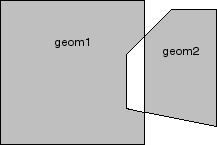
SDO_GEOM.SDO_XOR returns a geometry object that is the topological symmetric difference (XOR operation) of two geometry objects. In Figure below, the shaded area represents the polygon returned when SDO_XOR is used with a square (geom1) and another polygon (geom2). References: https://docs.oracle.com/cd/B28359_01/appdev.111/b28400/sdo_objgeom.htm SDO_GEOM.SDO_XOR returns a geometry object that is the topological symmetric difference (XOR operation) of two geometry objects.
In Figure below, the shaded area represents the polygon returned when SDO_XOR is used with a square (geom1) and another polygon (geom2).
References: https://docs.oracle.com/cd/B28359_01/appdev.111/b28400/sdo_objgeom.htm
Question 8
Identify the partitioning type that is supported in Oracle Spatial.
- HASH
- RANGE
- INTERVAL
- LIST
- COMPOSITE
Correct answer: B
Explanation:
Oracle’s scalable database architecture includes partitioning, in which a single logical table and its indexes are broken up into one or more physical tables, each with its own index. There are many different ways to partition data, however this paper will focus on range partitioning with Oracle Spatial. Range partitioning is the currently the only partitioning scheme used with spatial indexes. References: http://download.oracle.com/otndocs/products/spatial/pdf/spatial_wp10_bestprac.pdf (page 3) Oracle’s scalable database architecture includes partitioning, in which a single logical table and its indexes are broken up into one or more physical tables, each with its own index. There are many different ways to partition data, however this paper will focus on range partitioning with Oracle Spatial. Range partitioning is the currently the only partitioning scheme used with spatial indexes.
References: http://download.oracle.com/otndocs/products/spatial/pdf/spatial_wp10_bestprac.pdf (page 3)
Question 9
How is the outer ring rotation defined?
- counterclockwise
- clockwise
- does not matter
- depending on the type of polygons
Correct answer: A
Explanation:
Outer rings should be counterclockwise, inner rings clockwise. References: http://download.oracle.com/otndocs/products/spatial/pdf/spatial_wp09_bestprac.pdf (page 6) Outer rings should be counterclockwise, inner rings clockwise.
References: http://download.oracle.com/otndocs/products/spatial/pdf/spatial_wp09_bestprac.pdf (page 6)
Question 10
To convert an SDO_GEOMETRY object to a GML object, special consideration must be given to the SDO_GEOMETRY object that is to be converted.
Which operation should be completed before SDO_UTIL.TO_GMLGEOMETRY is used?
- All geometries should be converted to LRS geometries.
- All points should be labeled.
- Circular arcs and circlers should be densified.
- The SRID in user_sdo_geom_metadata should be updated to 54004.
- All polygons with holes should be removed.
Correct answer: C
Explanation:
Any circular arcs or circles must be densified (using the SDO_GEOM.SDO_ARC_DENSIFY function) or represented as polygons (using the SDO_GEOM.SDO_BUFFER function) before being passed to the TO_GMLGEOMETRY function. Note: SDO_UTIL.TO_GMLGEOMETRY converts a Spatial geometry object to a geography markup language (GML 2.0) fragment based on the geometry types defined in the Open GIS geometry.xsd schema document.This function does not convert circles, geometries containing any circular arcs, LRS geometries, or geometries with an SDO_ETYPE value of 0 (type 0 elements); it returns an empty CLOB in these cases. Incorrect Answers:A: LRS geometries must be converted to standard geometries (using the SDO_LRS.CONVERT_TO_STD_GEOM or SDO_LRS.CONVERT_TO_STD_LAYER function) before being passed to the TO_GMLGEOMETRY function.E: For a polygon with holes, the outer boundary must be stored first in the SDO_ORDINATES definition, followed by coordinates of the inner boundaries.References: https://docs.oracle.com/cd/B28359_01/appdev.111/b28400/sdo_util.htm#SPATL1249 Any circular arcs or circles must be densified (using the SDO_GEOM.SDO_ARC_DENSIFY function) or represented as polygons (using the SDO_GEOM.SDO_BUFFER function) before being passed to the TO_GMLGEOMETRY function.
Note: SDO_UTIL.TO_GMLGEOMETRY converts a Spatial geometry object to a geography markup language (GML 2.0) fragment based on the geometry types defined in the Open GIS geometry.xsd schema document.
This function does not convert circles, geometries containing any circular arcs, LRS geometries, or geometries with an SDO_ETYPE value of 0 (type 0 elements); it returns an empty CLOB in these cases.
Incorrect Answers:
A: LRS geometries must be converted to standard geometries (using the SDO_LRS.CONVERT_TO_STD_GEOM or SDO_LRS.CONVERT_TO_STD_LAYER function) before being passed to the TO_GMLGEOMETRY function.
E: For a polygon with holes, the outer boundary must be stored first in the SDO_ORDINATES definition, followed by coordinates of the inner boundaries.
References: https://docs.oracle.com/cd/B28359_01/appdev.111/b28400/sdo_util.htm#SPATL1249
HOW TO OPEN VCE FILES
Use VCE Exam Simulator to open VCE files

HOW TO OPEN VCEX AND EXAM FILES
Use ProfExam Simulator to open VCEX and EXAM files


ProfExam at a 20% markdown
You have the opportunity to purchase ProfExam at a 20% reduced price
Get Now!